
CURRENT AFFAIRS | 11 OCTOBER 2026
A powerful earthquake of magnitude 7.7 struck Panama on Friday, 9 October 2026. According to the United States Geological Survey (USGS) event page (event ID us6000u18k), the quake struck at 17:56:06 UTC — 12:56 PM local time and 11:26 PM in India — about 12 km west-south-west of Pitaloza Arriba, in central Panama, at a shallow depth of about 12.6 km. The USGS first reported the quake as magnitude 8, then revised it to 7.6, and later settled on 7.7, as The Hindu (via the Associated Press) reported on 10 October.
For a CLAT aspirant, the event is a ready-made link between a current headline and static geography: plate tectonics, the Pacific “Ring of Fire”, the difference between magnitude and intensity, and how international agencies such as the USGS turn raw seismic data into an alert for governments and relief agencies.
What Happened on 9 October
The USGS estimates that about 4.6 million people experienced moderate (Modified Mercalli Intensity V) to severe (MMI VIII) shaking. Its PAGER system issued a red alert for economic losses, estimating losses at 3–30% of Panama’s GDP, and an orange alert for shaking-related fatalities. A red PAGER alert does not mean losses have been counted; it means the model judges very large losses likely and international help may be needed.
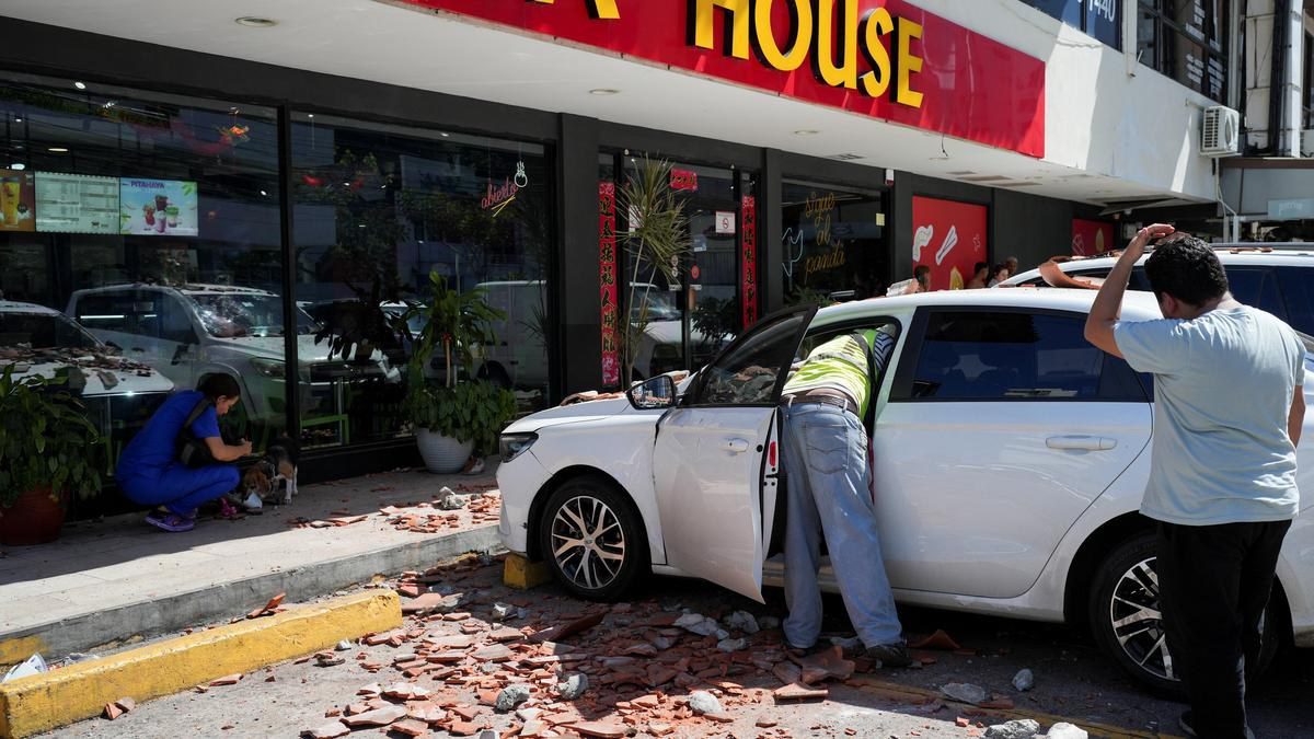
The Hindu/AP report noted that the quake was felt as far away as neighbouring Colombia, and that damage was concentrated in the central provinces of Veraguas, Herrera and Los Santos. A partial collapse and cracks were reported at a cathedral in the city of Penonomé, and a colonial-era church in Los Santos province was reported to have collapsed. Tocumen International Airport in Panama City briefly suspended operations while safety checks were carried out.
Aftershocks followed through the day. USGS recorded a magnitude 6.6 aftershock on the evening of 9 October (UTC), and a magnitude 6.0 aftershock early on 10 October. A tsunami threat was issued for parts of Central America’s Pacific coast and was later lifted after the Pacific Tsunami Warning Center said no threat remained.
On the human toll, preliminary counts from Panama’s National Civil Protection System (SINAPROC), as reported by Reuters and other outlets, put the number of people injured at about 27, mostly minor injuries, with no deaths reported. These figures were still being updated as damage surveys continued in rural areas.
Importantly for global trade, the Panama Canal Authority said operations were continuing normally, while specialised technical teams inspected its facilities for possible damage.
Background & Framework
Plate setting: The USGS tectonic summary explains that Panama sits on the Panama microplate, which is surrounded by the Cocos and Nazca plates to the west and south, and the Caribbean and South America plates to the north and east. The 9 October quake had a left-lateral strike-slip focal mechanism — the two blocks of crust slid past each other horizontally, rather than one diving beneath the other. USGS notes that earthquakes are frequent in the region, though most historical seismicity lies to the west, along the Panama Fracture Zone (the Cocos–Nazca boundary).
Ring of Fire: Panama lies on the Circum-Pacific Belt, popularly called the Ring of Fire — a roughly 40,000-km arc of volcanoes and fault lines around the Pacific Basin where most of the world’s earthquakes occur.
Earlier big quakes: USGS lists a magnitude 7.5 event (July 1934) and a magnitude 7.2 event (July 1962) in the region.
Magnitude vs Intensity: The Concept Behind the Numbers
Two different scales appear in every earthquake story, and examiners love to test the difference.
- Magnitude measures the energy released at the source. It is a single number for one earthquake. The modern standard is the moment magnitude scale (Mw), which replaced the older Richter scale (developed in 1935 for local California quakes) because Richter values saturate for very large events. The USGS figure for Panama is “7.7 Mww” — a moment magnitude calculated from W-phase waves.
- Intensity measures the shaking and damage felt at a particular place. It varies from place to place for the same quake. The commonly used scale is the Modified Mercalli Intensity (MMI) scale, written in Roman numerals from I to XII.
Both scales are logarithmic in spirit but not interchangeable: one magnitude step represents roughly 32 times more energy released, while intensity is a descriptive ranking of effects. That is why the USGS can say one 7.7 quake caused “moderate to severe” shaking (MMI V to VIII) depending on distance from the epicentre.
Why Early Magnitudes Change
The revisions from 8 to 7.6 to 7.7 are normal. The first estimate is produced within minutes from limited station data so that tsunami centres and governments can act quickly. As more seismic records arrive from distant stations, scientists compute more reliable moment-magnitude solutions, and the figure is updated. The Panama case is a good example of why exam questions usually rely on the “final” figure published by the agency.
What Is PAGER?
PAGER — Prompt Assessment of Global Earthquakes for Response — is a USGS system that combines the shaking map with population and building-vulnerability data to estimate likely fatalities and economic losses. It issues colour-coded alerts: green, yellow, orange and red. Panama’s red alert was for economic losses; the fatality alert was orange. The alert is a planning tool for responders, not a casualty count.
The Panama Canal Link
The Panama Canal connects the Atlantic Ocean (via the Caribbean Sea) with the Pacific Ocean across the Isthmus of Panama. It opened in 1914 and was handed over to Panama’s control at the end of 1999 under the Torrijos–Carter Treaties of 1977. The canal is one of the world’s key maritime chokepoints, which is why the Canal Authority’s statement that operations continued normally was closely watched by shipping markets.
The CLAT Angle
CLAT General Knowledge passages often start with a news event and then test the concept behind it. A passage on the Panama earthquake could ask:
- Which plates interact near Panama (Cocos, Nazca, Caribbean, South America)?
- What is the difference between magnitude and intensity, and which scale measures each?
- Which agency issues PAGER alerts, and what does a red alert indicate?
- What is a strike-slip fault, compared with a subduction (thrust) fault?
- Which two oceans does the Panama Canal connect, and when did Panama take control of it?
Watch for distractors such as “Richter scale measures intensity” (false — Richter is a magnitude scale) or “PAGER red alert means confirmed deaths” (false — it is a model-based estimate).
An India Connection: Seismic Zoning
India too sits on an active plate boundary, where the Indian plate pushes into the Eurasian plate along the Himalaya. The Bureau of Indian Standards earthquake code, IS 1893 (Part 1):2016, divides the country into seismic zones II to V, with Zone V being the most severe. Building codes based on such zoning are the main reason why well-built structures survive strong shaking. Panama’s experience — with damage concentrated in older churches and rural houses, and no deaths reported in early counts — underlines the importance of enforcing earthquake-resistant construction.
Analysis
Three takeaways stand out. First, a shallow strike-slip quake of magnitude 7.7 can shake millions of people even far from a subduction trench. Second, early warning and rapid assessment tools — tsunami alerts, PAGER, live-updated magnitudes — have become central to disaster governance, and they explain why initial numbers in news reports change. Third, the episode shows how a local hazard can have global economic interest when critical infrastructure such as the Panama Canal lies within the shaking zone.
Key Facts
- Date: Friday, 9 October 2026, 17:56:06 UTC (12:56 PM local; 11:26 PM IST).
- Magnitude: 7.7 Mww (USGS event us6000u18k); first reported as 8, then 7.6.
- Location: about 12 km WSW of Pitaloza Arriba, central Panama.
- Depth: about 12.6 km (shallow).
- Mechanism: left-lateral strike-slip faulting.
- About 4.6 million people felt moderate (MMI V) to severe (MMI VIII) shaking.
- USGS PAGER: red alert for economic losses (3–30% of Panama’s GDP); orange for fatalities.
- Aftershocks of magnitude 6.6 (9 Oct) and 6.0 (10 Oct).
- Tsunami threat issued for Central America’s Pacific coast, later lifted.
- Early SINAPROC counts: about 27 injured, no deaths reported.
- Panama Canal operations continued normally, according to the Canal Authority.
- Plates nearby: Cocos, Nazca, Caribbean and South America.
Memory Hook / Mnemonic
“C-N-C-S around the Canal” — Cocos and Nazca to the west and south, Caribbean and South America to the north and east.
“M is for Moment (energy), I is for Intensity (impact)” — Magnitude = one number at the source; Mercalli intensity = many numbers on the ground.
“8 → 7.6 → 7.7” — the three USGS readings; remember the last one.
Practice Quiz — 10 CLAT-Style Questions
Click an option to reveal the answer and explanation.